Well its been a good summer interning with the PHMC. Last week I
sat in on a seminar and was given an example of a situation in which
the PHMC has to handle at times. Apparently some of the Cultural
Resources data was inaccurate and it caused construction workers to
halt their work in order to preserve the site and develop an
alternative solution. An interesting scenario but important to grasp
because there might be a challenge like this in which I might have to
help manage someday. On Monday the intern coordinator offered a
farewell lunch for us at the Speakeasy. It was nice to have a final
meal with all of the amazing people I had the opportunity to work
with. On Tuesday, the Keystone interns were invited to attend a
planetarium show in the State Museum. The show was narrated by Tim
Allen and talked about how different organizations across the globe
are competing to develop a technological method for anyone to go to
the moon at an affordable price. Of course it is a very long stretch
but it was interesting to see some of the different innovations and
ideas the different groups focused on in order to achieve this goal.
Penn State apparently has a program to build a rocket and land on the
moon and travel at least 500 meters with a lunar rover on the
surface. I never knew there were so many people working on this. It
makes me feel great that we are developing technology which will
allow anyone to see this one day. I finished my Allegheny National
Forest map georeferencing for the summer. Hopefully I paved a road
well enough for future interns to pick up the pieces. During the week
I worked on presenting Esri Storymaps regarding the internship and
the various places I traveled and the project I worked on. The links
to these maps are provided below. Everyone was very amazed that there
was such amazing technology available. My supervisor suggested I
should share the Ephrata Cloister storymap with the staff of the site
down in Lancaster. I will show it to them once I get the chance. I
have to say, with all the trips and seminars I attended this summer
this was a fantastic internship and a great opportunity to understand
the efforts that the PHMC puts out in order to help keep the state of
Pennsylvania the way we see and know it.
Allegheny Oil Fields - My main work for the PHMC:
http://hacc.maps.arcgis.com/apps/SimpleViewer/index.html?appid=d95ec353b00345779248e590f041ae95
Trip to the Allegheny National Forest:
http://hacc.maps.arcgis.com/apps/MapJournal/index.html?appid=7a892940201447e8aa24702f5d907f1e&webmap=618903d1389e41a4a960955e509a4cda
Layout of the Ephrata Cloister:
http://hacc.maps.arcgis.com/apps/MapTour/index.html?appid=e3dab6f01ed146deab7769bfbb3dc86f&webmap=b8a3493f8ae249e2bb47737d8bc8f321
Friday, August 1, 2014
Tuesday, July 22, 2014
Philadelphia was an awesome experience!
Philadelphia was a blast! Last week I attended FORUM 2014. It was a conference on cultural preservation on buildings, landmarks, structures, and other various properties which are under historic preservation within Pennsylvania. This year was different than most because there were many attendees who work all over the country. My job along with the other interns was to be the conference staff. This involved setting up computers and projectors, greeting guests, directing where everyone is to go, and put items and other registration materials together such as badges and bags with directories. Since I have been to various conventions before I already had a very good idea of what to expect. While setting up the equipment in one of the rooms, there was a problem getting the signal from the computer over to the projector. I had to ask a couple of my fellow interns for help but they couldn't find out the problem. Finally, my coworker in the PHMC figured out the laptop wasn't working right. After switching to a few different laptops, we found one which transferred the signal. During the conference, I attended numerous meetings. One of meetings I found very interesting about archaeology and other historical artifacts found in the ground. There was a lady speaker who looked upon artifacts as unique treasures and used them as visuals to tell the story of various historical people's lives back in the day. Other than sitting in the meetings I had the opportunity to talk to other various attendees about what they did and what I am currently working on with the PHMC. Many work in archaeology and architecture. The company WJE (Wiss, Janney, Elstner Associates, Inc.) had a booth there which I looked into quite a bit. They specialize in architectural repair and one of their most notable projects was repairing the Washington Monument after the 2011 Virginia earthquake. A video showed the internal and external damage to the structure. Many cracks and small pieces of debris were found throughout it. One of the best places I visited during the conference was the Reading Terminal Market. The FORUM rented it out one night to hold a reception. The food was very good there. After the conference, the interns and I took a day-long field trip to Lancaster. In the morning we stopped at the Ephrata Cloister. It was an awesome experience learning the backgrounds about the founder and the people who lived there. It was a religious village primarily used by pilgrims who escaped the Holy Roman Empire in Europe for religious freedom. They had nowhere else to go and they were given food, shelter, and the freedom to practice their faith. In the afternoon, our tour led us to the Pennsylvania Railroad Museum. It was awesome seeing the many old steam engines which used to define our state's economy. In addition to the tour all the interns were given a special privilege to see a steam engine getting fixed up to be displayed. Seeing it up close was spectacular! So much effort and research goes into making these things look finished and historically accurate for its time. I can understand why the PHMC doesn't only want me to learn about the GIS aspect of my internship, they want me to learn about everything the commission does and about Pennsylvania's history. It helped me understand what GIS is for the state of Pennsylvania. I am almost done with plotting the oil fields and historical wells. Pretty soon I will have a project manageable for future GIS interns to pick up the pieces and work on.
Sunday, July 13, 2014
Many exciting trips and tours!!
 In the past week me and a couple of the other interns took a trip
up to the Allegheny National Forest in order to get a hands-on feel
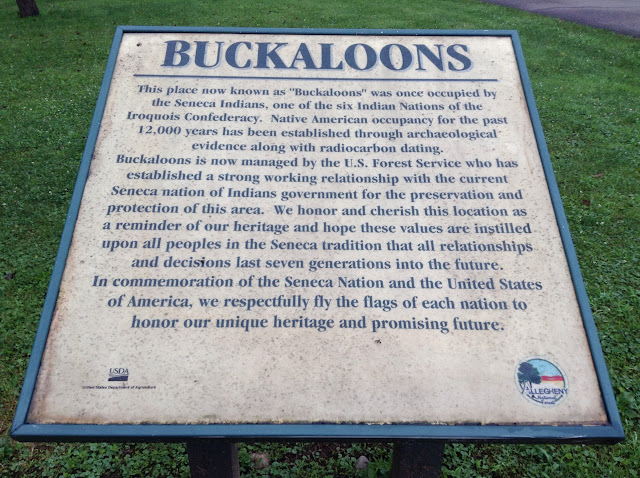
of our work. We stayed in Warren County and looked at the Buckaloons
and Loleta State Parks. The Buckaloons area had a town called
Irvineton, it was owned by a wealthy family known as the Irvines. The
family invested in oil which helped me in georeferencing the
historical maps. One of the maps showed an area rich in oil close to
their estate! It was exciting seeing out the other interns projects
and mine combining. During the trip in what was left of Irvineton, we
got a tour of what was left of the old Irvine estate. Unfortunately,
the property has been demolished. Archaeologists on site showed us
the footprints and other various locations of what remained of the
estate. Trees and other vegetation has completely taken over what
used to be a rich family mansion. The ice house where the family
stored ice was still intact. There have been rumors there was a
secret passage in it which led to the kitchen. There wasn't any proof
though and no proof saying there was no passage so it could actually
be possible. Our next stop was Loleta. Loleta was a project made by
the Civilian Conservation Corp during the years of the Great
Depression to bring tourists to the forest. There was a pool area
which the CCC beautifully
In the past week me and a couple of the other interns took a trip
up to the Allegheny National Forest in order to get a hands-on feel
of our work. We stayed in Warren County and looked at the Buckaloons
and Loleta State Parks. The Buckaloons area had a town called
Irvineton, it was owned by a wealthy family known as the Irvines. The
family invested in oil which helped me in georeferencing the
historical maps. One of the maps showed an area rich in oil close to
their estate! It was exciting seeing out the other interns projects
and mine combining. During the trip in what was left of Irvineton, we
got a tour of what was left of the old Irvine estate. Unfortunately,
the property has been demolished. Archaeologists on site showed us
the footprints and other various locations of what remained of the
estate. Trees and other vegetation has completely taken over what
used to be a rich family mansion. The ice house where the family
stored ice was still intact. There have been rumors there was a
secret passage in it which led to the kitchen. There wasn't any proof
though and no proof saying there was no passage so it could actually
be possible. Our next stop was Loleta. Loleta was a project made by
the Civilian Conservation Corp during the years of the Great
Depression to bring tourists to the forest. There was a pool area
which the CCC beautifully 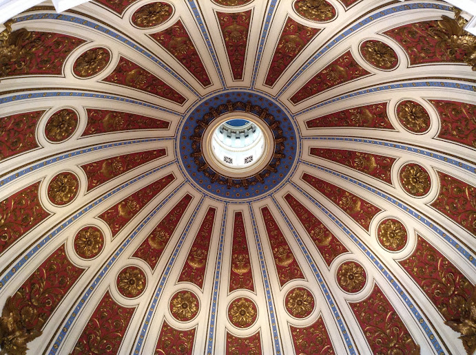 constructed. Several cabins were
constructed around the site to be a functional recreation area. Later
I got to see old historical blueprints of Loleta layout at the
Alleghany Forest Office. It was a great experience going up there and
seeing a part of Pennsylvania that I have never been to before.
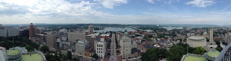
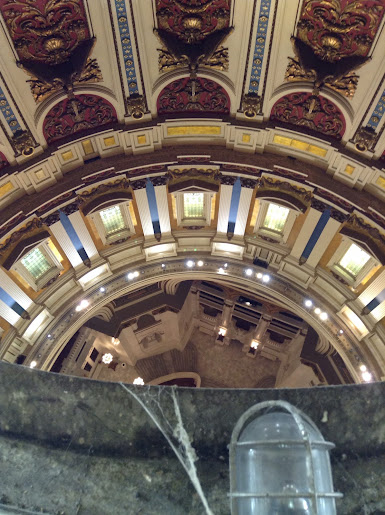
Another very exciting tour I just went on was seeing the inside of
the capitol dome! The Keystone Interns had a very special and rare
opportunity to go inside and look around the structure. It was
incredible! There was a ring passageway around the base of the dome
and doors leading right to the interior balcony looking down at the
rotunda! After climbing a number of ladders, I was in a crawlspace,
it turns out the state capitol is two domes with an outside and
inside dome. While climbing up inside, I could see the windows which
decorate the outside and light up at night! At the top of the
crawlspace, there were a few windows for ventilation which was at the
very top centerpiece section. I managed to sneak a picture above at
the night sky painting and at the staircase way below. There was a
hatch at the top, which led outside to the top section right under
the Statue of Commonwealth. Words cannot describe the view and the
experience. My next challenge in the oil field mapping was
georeferencing. At first it doesn't seem like its all that hard.
Turns out most of the maps are broken into section pieces. Once I
georeferenced them on the computer, I found out none of them were
proportionate to each other at all. None of the polygons I was using
in order to georeference oil fields matched up. I restarted
georeferencing and focused on the the county borderline. This was
better but considering the fact the historical maps I was using were
not proportionate completely to the modern geographic surface
interfaces we use today, it was impossible to figure out how to
pinpoint the maps. I was one of my superiors if I should photoshop
the map in order to make it one map again and georeferencing easier.
After some thought he agreed and I photoshopped the map pieces. Due
to the age of the material, many edges have been torn, faded, or
constructed. Several cabins were
constructed around the site to be a functional recreation area. Later
I got to see old historical blueprints of Loleta layout at the
Alleghany Forest Office. It was a great experience going up there and
seeing a part of Pennsylvania that I have never been to before.
Another very exciting tour I just went on was seeing the inside of
the capitol dome! The Keystone Interns had a very special and rare
opportunity to go inside and look around the structure. It was
incredible! There was a ring passageway around the base of the dome
and doors leading right to the interior balcony looking down at the
rotunda! After climbing a number of ladders, I was in a crawlspace,
it turns out the state capitol is two domes with an outside and
inside dome. While climbing up inside, I could see the windows which
decorate the outside and light up at night! At the top of the
crawlspace, there were a few windows for ventilation which was at the
very top centerpiece section. I managed to sneak a picture above at
the night sky painting and at the staircase way below. There was a
hatch at the top, which led outside to the top section right under
the Statue of Commonwealth. Words cannot describe the view and the
experience. My next challenge in the oil field mapping was
georeferencing. At first it doesn't seem like its all that hard.
Turns out most of the maps are broken into section pieces. Once I
georeferenced them on the computer, I found out none of them were
proportionate to each other at all. None of the polygons I was using
in order to georeference oil fields matched up. I restarted
georeferencing and focused on the the county borderline. This was
better but considering the fact the historical maps I was using were
not proportionate completely to the modern geographic surface
interfaces we use today, it was impossible to figure out how to
pinpoint the maps. I was one of my superiors if I should photoshop
the map in order to make it one map again and georeferencing easier.
After some thought he agreed and I photoshopped the map pieces. Due
to the age of the material, many edges have been torn, faded, or


Monday, June 30, 2014
ArcMap systems a go!
I have been getting more confident using the Cultural Resources GIS database. It is a challenge to understand which labels housing properties would fall under. Not all fall in the same category or is black and white. There are many properties which are being reviewed for demolition. There was a case where I was researching a site and making sure the properties fell in the same locations on the historical maps obtained in the documents. I compared it using Google Maps. It took me a little while to match up the houses and structures. The documents also came with photographs. Looking at the photographs I could pinpoint the exact grounds they were all located in. After a close look with some of the sites, I figured out that some farm storage sheds were completely demolished before the PHMC could draw a conclusion if the structures were eligible or not. With that, I added to the database that the farm sheds were completely demolished and was told that it is common when structures are reviewed to be demolished. There is nothing which can be done though. In addition to learning more in depth to the cultural resources, I attended a meeting to understand how the PHMC's budget system works. They also addressed, the Pennsylvania State Archives will be moved to another facility which is yet to be built. The archives tower will be replaced with The State Museum's artifacts for extra storage room. The site of the new archives will be very close to HACC's Wildwood campus. It is across from Cameron Street and somewhere next to the USPS building. I am disappointed though because I always saw the State Archives as a facility in full collaboration with the museum. With it going to a new spot, it would be awfully more difficult to travel back and forth. I liked the idea of having Pennsylvania's history in one spot. Change is inevitable so I guess I have to look at the positives this change will present. In addition, ArcMap is now completely installed (finally) and I have already begun georeferencing a large historical map of Warren County's oil fields. It was in a total of nine pieces. It was a challenge to match up the points because the roads and natural landmarks such as lakes, streams, or swamps were out of proportion due to the fact that it was hand drawn and the person rendering used information based on various people's accounts. Overall I matched up the map the best I could and I think it is a good result for this project.
Sunday, June 22, 2014
Getting down to business...
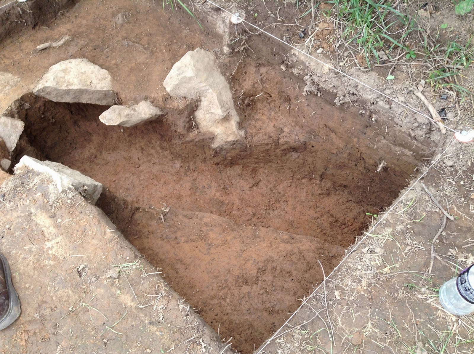
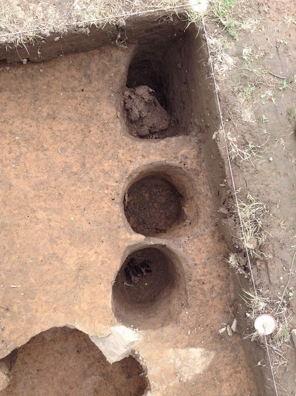
Sorry for the delay in posts, the main GIS project didn't begin until now. Within the past couple of weeks I was assigned to map out the historical oil fields within the Alleghany National Forest. To accomplish this, printed copies of documents had to be organized to look up as a reference. The next step is to use these documents and compare them to various historical maps of oil fields which are stored inside the Pennsylvania State Archives. Before I got into the project, Tom invited me to attend an all-day oil and gas summit which was to help me learn how significant oil and gas is for the state of Pennsylvania. Various agencies from the state such as the Game Commission, DCNR, DEP, and the USGS were there. From what I have learned, Pennsylvania has many precious natural landmarks and resources some of which is more unique than many other states. For example, Devil's Den and The Hickory Run Boulder Field are very unique formations. None of which will be found in other states. After the summit, Tom and I went into the archives to find historical oil fields in the Alleghany National Forest. I looked on the archive's online database for historical maps I figured would have significant information for the project. After extensive searching, I typed up a list of the maps we needed and gave it to the archive manager. Once obtained, it took about a half-hour to figure out all the maps which were useful and not useful. I had to look hard at some of them to determine if they were significant. The data pertaining to oil fields was not all the same. Some were portrayed as dots while others had slightly shaded circles. It threw a curve in my head thinking the polygon circles could be a potential site. I looked harder at other maps and found out that there were fields labeled by company. I felt more confident understanding and picking out the data I needed on my own. Tom helped me a lot too, but I truly felt I took a larger step in understanding how to find data. Once we figured out the maps we needed and did not need, they were scanned and automatically sent into one of our computer drives. The maps will be georeferenced into ArcMap so the points can be plotted. Unfortunately, ArcMap had not yet been installed on our computers. I used ArcMap on a virtual machine but it kept freezing up and was only fortunate to georeference only one map. I has told ArcMap will be installed and running this week on the server. It is sad to say the project has been temporarily paused. Along side the Allegheny National Forest project, me and the other Keystone Interns got a tour of the state capitol in the past week. The tour guide told us the Capitol was completely restored around twenty years ago for an effort to restore its historical significance. Before the restoration, walls were leaking and one of the large paintings near the dome was pealing off. The marble throughout the building was yellowed due to the legalization of smoking inside for many years. There is a video link below about the Capitol Rotunda's restoration. In addition to the tour, I also got to see an archaeological dig or Fort Shirley. Located near Shirleysburg in Huntington County, Fort Shirley was a defense fort used by British America during the French and Indian War. The site surprisingly was on a private farmland and the owners were nice enough to allow Penn State to do excavation which started in 2009. There were scattered excavations throughout the property. Some of the artifacts recovered were indian arrowheads, British flint, and a coin from the 1700's. There was also evidence in the soil from trenches that indians dug around the fort. Deep down there were decayed remains of wooden posts used in the fort's outer walls. With the posts and the trenches, the excavator's were able to draw a rough outline sketch of the size and shape of Fort Shirley. From what I was told this is one of the very few significant archaeological excavated sites anyone will find in Pennsylvania. Photos are also posted.
Capitol Rotunda Restoration
https://www.youtube.com/watch?v=i2VtetVQ0fc


Monday, June 2, 2014
The Pennsylvania Museum Commission has obtained many records of specific sites within the Allegheny National Forest. These sites contain evidence found of possible archaeological sites. It is the duty of the PHMC (Pennsylvania Historical and Museum Commission) to tell agencies or other organizations who might have potential plans for construction where not to build or where it intersects possible damage to rich nature habitats. There is a problem with this, most archaeological locations and records are not entered in the database of the PHMC. Most records go back to the 1980's and would take forever for state workers to figure out if construction sites are safe. Locations also need to be entered in the PHMC's Cultural Resource Database using GIS (Geographical Information Systems). Several interns including myself are working on the project this summer to help clean up the mess and begin organizing it. To begin, the other I have started looking through stacks of documents and sorting out which archaeological findings are considered as actual "sites" and which are non-sites. There are so many conditions to make a finding a site, probably even more than I will ever get to know. There is some basics which I have learned regarding an old architectural artifact. A building as to be at least fifty years old in order to be considered historical and must contain at least three objects within fifteen meters of each other. The staff are trained experts in archaeology so they know by reading the documents how the classify them so we can enter the correct data into the system. Eventually, the staff will assign me a specific project based on entering in data into the server and mapping of historic oil fields within the Allegheny Forest. Not only will it be beneficial in understanding where the sites are but it will also benefit the DEP (Department of Environmental Protection) in understanding how all the wells within specific areas and even as a whole correlates together. While this is all part of the Keystone Internship program, the staff at the PHMC have given the opportunity for interns to attend specific meetings and tours regarding the functions and history of Pennsylvania for everyone to understand what the museum stands for and the rich history it all surrounds all of us. During the orientation meeting, all the interns were given a tour of the museum and all of its compounds. In addition, we got to tour the rooms where artifacts are all stored and cleaned. The State Archives works with the PHMC in storing documents and records. We got to see archive tower and one of the various levels of document preservation. I have learned the storage facility stays dark for a reason and its to preserve the paper inside. Some documents in the archives contain very specific data from certain events, for example there are thorough health documents of people around the TMI (Three Mile Island) incident. This is all the more reason why information like this needs to be preserved, so records can be easily found if health records can be compared to effects of similar events. Other various documents are submitted on Ancestry.com so people can trace relatives, etc. Overall this is a great beginning and I am very excited to spend my summer at the PHMC!
Sunday, May 18, 2014
Welcome
This will be my blog about the projects I am working on at the Pennsylvania Museum Commission in Summer 2014.
Subscribe to:
Posts (Atom)